News and articles
-
 Read more about The National Land Survey will be photographing a third of Finland from an airplane
The National Land Survey will be photographing a third of Finland from an airplane
The National Land Survey has started its annual aerial photography and laser scanning season to collect crucial data to help strengthen comprehensive security. The data is also used by the forestry and environmental sector.
Press releaseSpatial dataAerial photography -
 Read more about Our customer service in Jyväskylä will open in a new location on 8 May
Our customer service in Jyväskylä will open in a new location on 8 May
The National Land Survey, the Digital and Population Services Agency and the Tax Administration will share the customer service space in the new location.
NLSServicesCustomer Service -
 Read more about Cottage owner’s checklist - where can you check plot boundaries, who can walk on the road?
Cottage owner’s checklist - where can you check plot boundaries, who can walk on the road?
Checklist with answers to cottage owners' most important questions.
Real propertyCadastral survey -
 Read more about Research shows that flood periods have become unpredictable
Research shows that flood periods have become unpredictable
The National Land Survey of Finland is participating in a study that has given indications that floods have started to shift from spring to other seasons.
Press releaseResearchLaser scanning -
 Read more about Researchers are developing and testing the detection of GNSS interference
Researchers are developing and testing the detection of GNSS interference
There is a dire need to solve the problem, as interference causes security risks and financial losses for the authorities and companies alike.
Press releaseFinnish Geospatial Research Institute (FGI)Research -
 Read more about Researchers discover that trees awaken to spring at their own pace, even within the same species in the same forest
Researchers discover that trees awaken to spring at their own pace, even within the same species in the same forest
A study by the National Land Survey of Finland and the University of Helsinki has revealed significant individual differences in how trees awaken for the growing season.
Press releaseFinnish Geospatial Research Institute (FGI)Research -
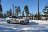 Read more about An autonomous car driving on the streets helps cities solve problems of the future
An autonomous car driving on the streets helps cities solve problems of the future
The Finnish Geospatial Research Institute’s self-driving car collects accurate data on its surroundings while driving on the streets of cities regarding, for example, the road conditions, carbon sinks in trees, and any needs to prepare for floods.
ResearchFinnish Geospatial Research Institute (FGI)Press release -
 Read more about Unusual anomaly in Antarctic glaciers
Unusual anomaly in Antarctic glaciers
Researchers of the National Land Survey of Finland’s Geospatial Research Institute and the Finnish Meteorological Institute have found that as Antarctic glaciers continue to melt, the thickness of the ice at Finland’s research station is growing.
Press releaseResearchLaser scanning -
 Read more about Finland has the potential of becoming a drone technology superpower
Finland has the potential of becoming a drone technology superpower
Eija Honkavaara, a pioneer in drone research, sees that Finland has all the prerequisites for success in drone technology, as long as the path from research results into business is in order.
Press releaseResearchFinnish Geospatial Research Institute (FGI) -
 Read more about Research by the NLS produced millions in benefits for society in 2024
Research by the NLS produced millions in benefits for society in 2024
Preparation for interference with satellite positioning, information about the state of the environment collected using drones, and observing the planet using satellites are a few of the research themes.
Press releaseResearchFinnish Geospatial Research Institute (FGI)
More information
For media
Our Communication Services assist media representatives in finding needed information, photographs and experts.